Saturday, 27 August 2016

Day 6. Welshpool to Crewgreen.


Saturday 27 August.

We stayed at the Westwood Hotel in Welshpool. We last stayed there 6 years ago whilst walking the Offa' s Dyke path. A friendly place with a good breakfast. However to reach it you have to cross a very busy road. All the town roads in Welshpool seemed ridiculously busy to us. However it should be noted we've now been away from the UK for 41 years.

We set off at 9:40 am in cool, overcast weather. We retraced our steps to the Montgomery Canal and headed north. The next picture is a canal view showing two sightseeing barges. Note the clear reflections in the water. There was little wind.

The next picture is of a giant fungus we saw beside the canal. The piece of paper in the photograph is standard width toilet paper, to help you guage the enormous size of the fungus.

In the next photo you can see two adult swans with seven cygnets. We did wonder if they were relatives of the ones we saw whilst walking Offa's Dyke 6 years ago.

Further along we passed a tilt bridge over the canal. We can't remember seeing such a bridge on the Leeds/Liverpool Canal last year.

The next view, through a farm gate, gives you an idea of the sort of misty morning we set off in.

The noise from the road near the canal, A483, was quite intrusive,  and for a short time the road, towpath and canal were running side by side, as in the next picture below.

The next two photographs are for the biologists amongst you. The first shows a small section of hedge, by the canal, that was covered with cobwebs, but why just the small section.

The next picture shows the red and green mats of algae which at time covered large area of the canal surface.

We eventually left the canal heading NE, across country  together following the Offa's Dyke path. The National Trail status of the Offa's Dyke path meant the path markings and maintenance were very good.

The next photo shows a distant view of the Breidden Hills,whilst in the fields near the path we are now starting to see the odd paddock of sweet corn here and there.

Having left the canal, the path headed NE and largely followed the stop bank either side of the Severn river. The river was much more docile than it appeared in the earlier days of our walk.

Eventually the Offa's Dyke path and the Severn Way path parted company. It was clear by now that the large hill on the horizon was actually being gradually removed from the landscape by a huge quarry works.

We passed a brick bridge over the Severn, which was there during the second world war and  we've also attached a picture of  the concrete pill box at the N end of the bridge built to protect it.

There were quite a lot of cattle on the path today and a few came over to inspect us.

The next photo shows a bend in the Severn where Japanese Knot weed seems to have become established. There was a lot on the Montgomery Canal yesterday.

The final photograph was taken above a small water way leading into the Severn. It seems to be an example of taking health and safety warnings to extremes.

Friday, 26 August 2016

Day 5. Newtown to Welshpool.

Friday 26 August.

A bright sunny day today, as you will see in the photographs below. We left our B&B, Yesterday's Hotel early, abput 9:40 am as we knew it was going to be a long day.

We initially walked beside the west bank of the Severn for about 2 to 3 km before passing the (Newtown?) sewage works, at which point the Montgomery canal started and the Severn way then followed the towpath of the canal rather than following the river Severn. It did this all the way into Welshpool a distance of 25 km or 15 miles.

Although the walk was totally flat between locks, where there was a slight descent,  the combination of pack weight, distance and heat made it an exhausting day. Perhaps we are getting old!

By latching on to the Montgomery canal the Severn Way was committed to close proximity to two roads.  Nearer Newtown the A483 and later, approaching Welshpool, the A458. The traffic noise was quite unpleasant at times.

In recent times new roads have been given precedence over the older canals and so continuous passage along the canal, by water, is no possible. Towpath walkers have to perform a number of busy road crossings.

We've added a few photos to give you an idea of what we saw on our way. Path conditon was good, no machetes needed, at least for towpath walkers. Trying to navigate the canal itself would be something else again. The southern end was completely impassable but things got clearer going north.

We saw men out trimming vegetation at the southern end , nearer Newtown. We appreciate there help. It would be good if their colleagues to the north, just entering Welshpool, could follow their example and do a bit of trimming.

Day 5. Newtown to Welshpool. Insert.

Friday 26 August.

We missed out the first 4  photographs of Friday's blog. They were taken when we were just leaving Newtown. They are added below.

We've been unable to edit the original blog to put them in the correct order. We'll try to blog these 4 first.

Thursday, 25 August 2016

Day 4 Caersws to Newtown. Sign Damage

We've attached photos below of a few damaged signs as we passed them today, in order of travel. My favourite is the finger post in the hedge which got 'trimmed' along with the hedge.

The last sign, a good one for comparison, was located just above Newtown. Has it been replaced recently pehaps? We usually find urban areas are worse for sign damage.


Day 4 Caersws to Newtown. Obstructions.

This supplementary blog shows 2 examples where downed trees block the path but one can still walk around the outside. One at least is pretty recent.

The 3rd photo shows where a tree has fallen over the path, probably much older.

The following 4 photos show examples of "unsafe" stiles, or at least we thought so.

Day 4. Caersws to Newtown.

Thursday 25 August.

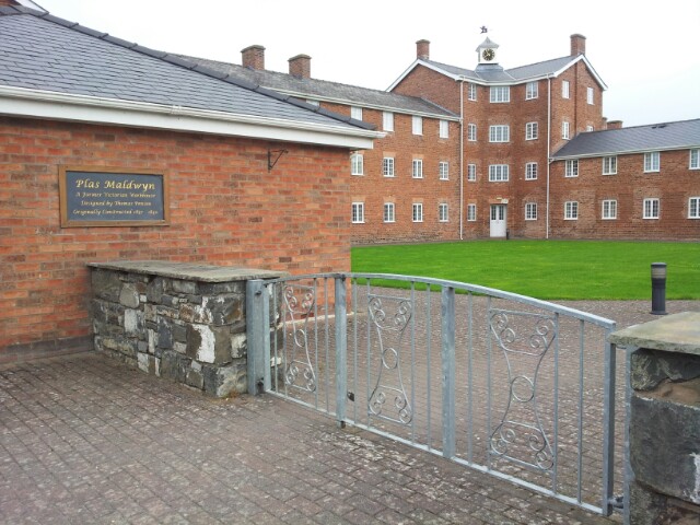
We left our B&B (MWAC)  at 10am, on a humid, overcast morning. We retraced our steps over the Severn, passing The Unicorn pub, where we ate yesterday evening and headed East out onto the main road. The first resident we saw was the Donkey shown below, he was in a paddock, just before the large Victorian workhouse which is in the next photo. It later became a mental asylum.

It was just past the workhouse where we crossed the road and entered a field with a view of the Severn (next photo). Notice the haze in the distance, and in the next photograph, which was taken a little further along. There was no rain until about 7pm and it was even sunny for a while around midday.

There was quite a lot of climbing today, the first bit of which was followed by a long walk through an avenue of oak trees. In one part a large piece of farm machinery had been dumped, but it was so long ago now that it was now surrounded by young trees.

We've mainly been meeting sheep on our walks, they quite often shot out my name, or at least it sounds like it. Today we met up with some cows and their calves, they were a bit skittish, but they were also very curious as to what we were up to.

The next photo shpws a good example, for us at least, of way marking. You can see a near way mark as well as one in the distance to get a bearing. As the next blog will show you can' t always rely on waymarkings to give you direction. You need a map and compass or gps maps. Even then we still go wrong, although we are getting btter as time goes on.

We passed a small lake with fishing pontoons,
before our final climb for the day. The final few miles were particularly bad for defaced signs and we've shown them in their own blog. We've also done a blockages blog. A few trees have fallen across the track in places.

The final bit into Newtown is pretty suburban with all the fencing that implies. See next photo.

We finally entered a parlike area before crossing a footbridge over the Severn with a fine view of the river.

A tiring but enjoyable day.